


| SERVICES | ||||||
ATG’s strong Technical team are capable of handling a wide gamut of geospatial projects in areas of photogrammetry, 3d modelling, orthophoto, geospatial mapping. |
||||||
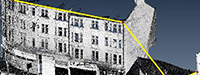
| PHOTOGRAMMETRY | DTM ORTHO | LiDAR MAPPING | GOLF COURSE MAPPING | |||
 |
 |
 |
 |
|||
| Photogrammetry services that can help you use your data for different fields, such as topographic mapping, architecture, engineering, manufacturing, quality control, police investigation, and geology. » Learn More |
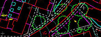
Get your data digitized, corrected or place linework, text annotations or geographic symbols, etc, that can be used for measuring accurate distances. » Learn More |
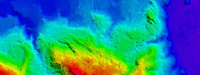
High resolution maps that can used for geomatics, archaeology, geography, geology, geomorphology, seismology, forestry, remote sensing, atmospheric physics. » Learn More |
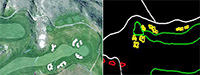
Get your golf courses mapped in detail. Asset Mapping of all Facilities, Buildings, Utilities and Golf Course/Park Foliage, Water and Hazards Mapping Irrigation and Landscape Mapping. » Learn More |
|||
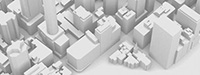
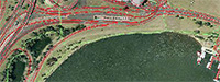
| 3D CITY MODELLING | 2D CONTEXTUAL MAPPING | LASER/MOBILE MAPPING | ||||
 |
 |
 |
||||
| 3D model generation that can be used for real life simulations in various software. » Learn More |
Digitization & attribution for features like Buildings, Transportation, Landuse, Structures, Complex & water in a Personal Geodatabase format by using inputs such as orthophotos. » Learn More |
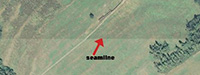
Get your laser mapping data corrected to reflect precision dimensions. » Learn More |
||||
| Need a service that is not listed here? Write to us and we might just be able to assist you with your requirements. | ||||||